Tuesday 14 July 2015

The Salkantay Trek to Machu Picchu

I thought it would be great to end the trip with a visit to the Incan ruins of Machu Picchu. As the Inca Trail needs to be booked months in advance, it was not an option. However it's possible to hike there independently via the Salkantay route over 4 days, so this is what I did.  While not the Inca Trail, it's still a challenging trek over a 4600 m pass with some top-shelf mountain scenery and wonderful camp sites along the way.

Arriving in shiny, touristy Aguas Calientes, the gateway to Machu Picchu, after 4 days in the wilderness was quite a shock. Fortunately I only had to go there to pick up my ticket and next morning at 5 am I was lining up with throngs of other tourists to see the sunrise over Machu Picchu. Despite all the tourists, I found it a magnificent and majestic place and well worth the visit. 

On the way back to Cuzco, I stopped off to visit some more Incan ruins in the town of Ollantaytambo. Smaller and more relaxed than Machu Picchu, it was a good chance to check out some of the incredible stone masonry of the Incans.

My time in South America is slowly coming to an end. It's been a wonderful experience but I'm feeling a little bit travel-weary after so many months on the road. Therefore, I've decided to return to Sucre in Bolivia a little bit earlier than planned and take some more Spanish lessons before I depart for London on 24 July.

The view hiking from Mollepata to Soraypampa. It feels good to be hiking to Machu Picchu.

 A friendly guy by his home.

Breakfast time shortly before Soraypampa. I met a Canadian guy called Chris and we hiked most of the day together.

Great flat hiking for beside a canal all the way to Soraypampa. Salkantay (6271 m) is coming into view on the right.

I pushed on to the pass at 4600 m, This is a view back down the valley towards Soraypampa.

On the pass.

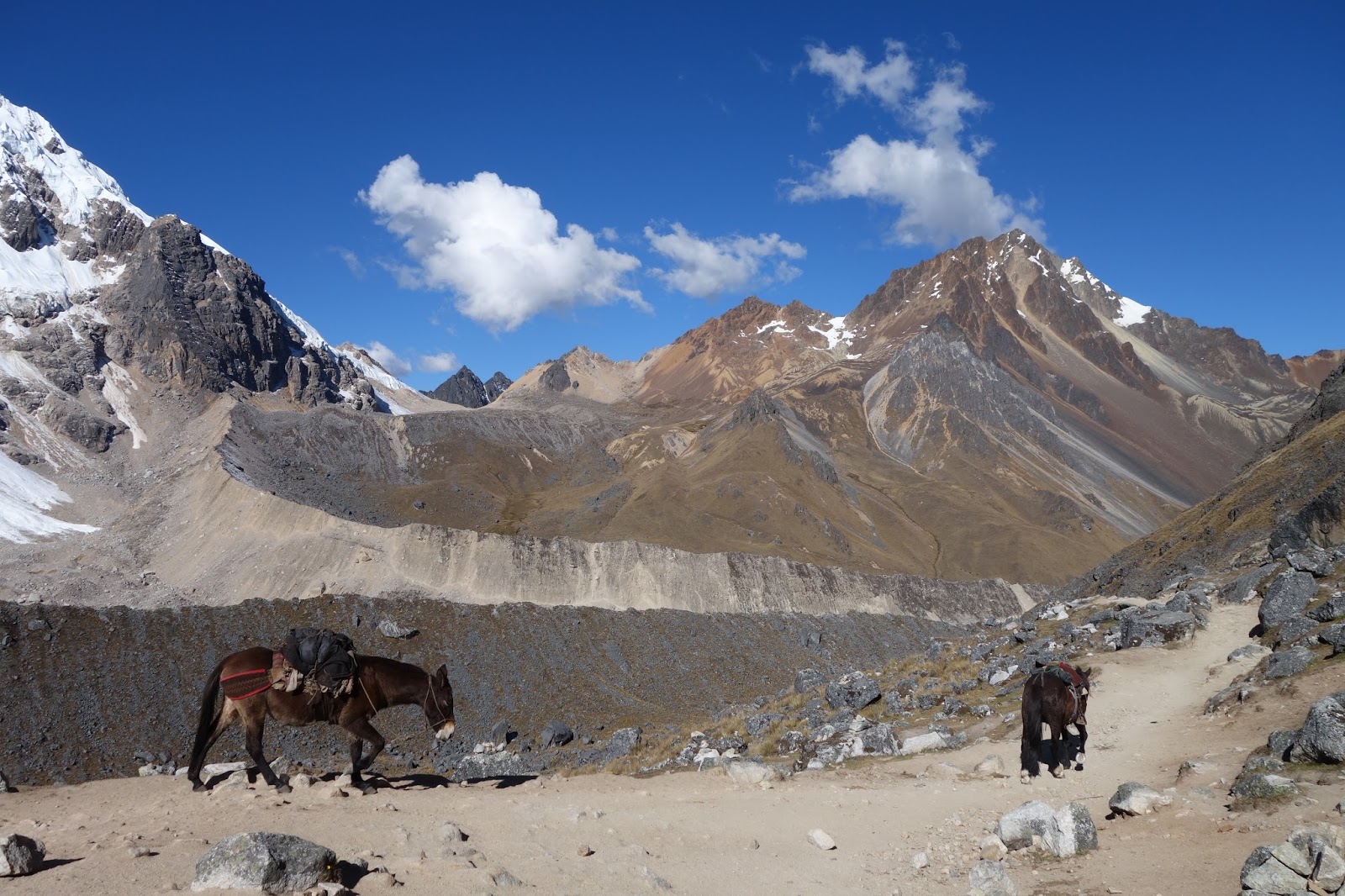
Pack horses for tourists on guided hikes are continually returning to Soraypampa.

Another top camping spot, about 500 m below the pass.

I carried this trek'n'eat for my whole South American trip as an emergency meal. Time to eat it.

Heading further down the valley the next morning.

A day later, and the climb to the Incan ruins at Llactapata passes through a coffee growing region. A veritable paradise, where all sorts of fruit grow in abundance.


Bananas, avocados, citrus, tree tomatoes, sugar cane, passionfruit and more...

Up through the subtropical jungle.

I reached the railway station called Hidroelectrica, and from there it was another 2 hours of hiking to the entrance gate of Machu Picchu. A long day.


The deep valleys near the entrance gate of Machu Picchu add to the feeling of isolation.

Before the sun strikes Machu Picchu, it strikes the surrounding peaks first.

Machu Picchu at sunrise.

The Inca Bridge, currently a bridge to nowhere.


Machu Picchu's isolated location in the mountains at 2453 m between Altiplano and jungle meant it remained undiscovered by the Conquistadors. The Incas abandoned it during the second half of the 16th century and it only became well-known in the West after Hiram Bingham's expedition in 1911. This photo was taken from near the Sun Gate.

Some details are pretty special, like the kingfisher in stone.

The astronomical observatory.

The Temple of the Sun is a good example of some of the incredible stone masonry perfected by the Incas. The granite stone was ideal for shaping.


Wednesday 8 July 2015

To the Land of the Incas

My overall goal was to reach Cusco and Machu Picchu in Peru. From Rurre in Bolivia's part of the Amazon Basin, I decided to take the long way - overland to Cobija on the Brazilian border, then just a short distance (100 km) through Brazil to IƱapari in Peru. From nearby Puerto Maldonado it would be another long river trip, this time up the Rio Madre de Dios to Shintuya in the foothills of the Peruvian Andes. After Shintuya, the climb through the clouds to Cusco is short and dramatic. 

The bus ride to Cobija was a rather monotonous 26 hour endurance test through the Pampas. The monotony was punctuated when the bus was loaded onto a barge to cross the mighty Beni and Madre de Dios rivers which eventually flow into the Amazon. For most of the way I was sitting on my backpack in the aisle as the bus was packed. I would have preferred my bike at that point! I'll remember my brief 6 hour visit to Acre province of Brazil for the contrasts with Bolivia: the physically larger people, officials sharply dressed in uniform, sealed roads, modern buses, plainer food, large farms rather than smalll landholders, and of course the different language. There were similarities too: the jungle in the area has been well and truly tamed, removed of its mysteriousness, and the people I met were just as open and friendly as in Bolivia. 

In Peru, I found a boat to take me up the Rio Madre de Dios to the village of Boca Manu. Only reachable by boat, Boca Manu sits on the edge of the Parc Nacional Manu, a 20,000 sq km expanse of pristine jungle that is home to some of the world's last remaining uncontacted tribes. There was a festival going on and many inhabitants of the surrounding indigenous villages had made boat journeys of up to 3 days to be present. The festivities included music, dancing, competions in volleyball, football and archery, and of course drinking. I was able to stay in the house of a local family and enjoyed the relaxed and friendly atmosphere. 

The boat trip upstream from Boca Manu to Shintuya was pretty forgettable in an underpowered little pekapeka longboat that struggled against the increasingly swift current. The boat leaked, it rained all day and we ran out of fuel. It was a relief to finally arrive in Shintuya and have a soak in the nearby hotsprings!

From Shintuya, a dirt road climbs 3000 m up through the clouds to the city of Cusco on the Peruvian Altiplano. It was another rapid and dramatic change of scenery mirroring my descent friom Sorata and brought my time in the Amazon Basin to an end. The area around Cusco was the centre of power of the Incas and home to most of their most famous architectural wonders, including Machu Picchu. Once I get used to the cold again, I'm looking forward to getting out for some more exploring. 

The bus trip from Rurre to Cobija took around 26 hours on a dusty dirt road through the Pampas.

To cross the Rios Beni and Madre de Dios, the bus was loaded onto a barge. A tug was used to maneuver the barge.

A bus crossing in the opposite direction.

Plenty of action on the other side of the Rio Madre de Dios (still in Bolivia).

Unsurprisingly, fish is a pretty common meal in these parts. Cost: about US$ 2.


Much further on, I reached the village of Boca Manu. It is also on the Rio Madre de Dios, but much further upstream and now in Peru. A festival to mark the 35th anniversary of the region was on.

I met some journalists from the regional newspaper and accompanied them to the nearby indigenous village of Isla de los Bayas. They interviewed the chief of the village (in traditional clothes in front of me) and we all drank masato. Masato is made from fermented yuca (a root) and tastes pretty awful, especially after 4 bowlfuls.

Typical accommodation in the indigenous village.

Between the Boca Manu and Islas de los Bayas is a bridge straight out of Tomb Raider.

I spent 3 nights with a friendly family in Boca Manu. This was their house with attached comedor (dining area).

The archery contest. Men from the surrounding indigenous villages lined up to compete.

A cook-up of beef and yuca for the whole village. I helped peel the yuca, which is a type of root.

Idyllic sunset over the Rio Madre de Dios at Boca Manu.

Chilling while heading upstream from Boca Manu to Shintuya.

The joys of travelling upriver in a leaky boat in the rain and then running out of gas. The hardships were all forgotten when I reached Shintuya and soaked in the nearby hotsprings. The next day I reached the town of Salvacion by moto taxi.

Get out!, she said

It's a rough road from Salvacion up and out of the jungle..

Finally I made it to Cusco!

Tuesday 7 July 2015

Welcome to the Jungle

After weeks on the Altiplano, I was ready to leave the cold nights and dry air behind and descend into the hot and humid jungle of the Amazon Basin. Having just been at over 6000 m above sealevel on Huayna Potosi, within a few days and a few hundred kilometers I was just 300 m above sealevel. It was a remarkable change in vegetation, landscape and cultures over a short time and distance.

From La Paz, I headed to the village of Sorata that sits on the edge of the Altiplano in the shadow of 6368 m Illampu. From here I hiked the precipitous dirt road down to the jungle, picking up rides as and when they came along. I was soon in the clouds and with the humidity the vegetation increased. As I descended, following the Mapiri river, I passed many goldmining operations on the steep and deforested slip-prone hillsides. The ramshackle town of Santa Rosa with its row of empty nightclubs waiting for lucky goldminers to walk in was the hub of activity in the region. Further on I reached Guanay, now well and truly in the jungle, and found a boat to take me down the Rios Kaka and Beni to Rurrenabaque. The trip took 3 days with two nights of camping on the riverbank. As I floated through the lush green jungle with its bugs, humidity, technicolour sunsets and nocturnal cacophony of animal sounds, the stark, cold beauty of the Altiplano seemed a distant memory. 

In Rurre I was back on the Gringo Trail and celebrated my birthday with a 3 day tour to the Pampas, where I swam with river dolphins, fished piranhas and spotted caymans, turtles, monkeys, capybaras, a sloth and lots of birds. It was a lot of fun. Swimming in murky water with caimans and piranhas and then having a curious dolphin brush my leg and nibble my big toe was something I won't forget quickly. 

On the way to Sorata...not the most flattering portrait of this local offical.

Sorata sits in the shadow of 6368 m Illampu.


It could also be on the French or Italian Riviera.

The way ahead. I travelled by bus as far as Tacacoma.

Tacacoma was shrouded in mist in the mid afternoon.


After spending the night in Tacacoma, I hiked down into the clouds...


...and it was a long way down.

Lower down, everything was wetter, greener.

I made good progress thanks to rides from locals. I had a spot in the back.

There were many gold mines along the way, including this one near Santa Rosa.


Finally at Guanay I could continue my journey by boat on the Rio Kaka.


Ruben, el Capitan.


Ruben's boat. Early morning mist was the norm.


A Chinese-run goldmining dredge.


Cacao is grown by the indigenous people living near the river bank. The pulp is quite tasty and sweet, while the beans are used to make chocolate.


Drying the beans.

A butterfly enjoying some papaya seeds.

A capybara on the riverbank. Wildlife was not that prevalent, as the animals have to compete with humans living in the area.

Leaving the mist behind and approaching Rurrenabaque.


Boats lined up on the riverbank at Rurrenabaque. From here I took a tour to the Pampas, where wildlife can be more easily spotted.

Hoping no caimans were lurking, we jumped in the river and waited for the river dolphins. They didn't take long to arrive.

Squirrel monkeys.


A caiman, which is a type of alligator specific to South and Central America. This one was about 3 m long.

The turtle and the butterfly.


We went fishing for piranhas and managed to catch about 10. They are pretty tasty fried up with a bit of lime juice.


Our hunt for an anaconda in the swamp was not so successful...


We were lucky to spot a 3 toed sloth making his way down a tree trunk.


There was a huge amount of birdlife in the Pampas.


Madrugada.


What lurks beneath...